Don't let a little snow (or even a lot!) stop you from hiking and exploring Mono County’s trails during the winter months! Famous for exceptional skiing and snow sports, the county also offers plenty of opportunities for "walking in a winter wonderland," especially at lower elevations. Read below about 15 favorite areas to walk and hike off-season, as well as tips for a safe, enjoyable experience!
California's reliable, year-round sunshine makes winter hiking in Mono County a magical adventure. Familiar summer landscapes are transformed into holiday card vistas with diamond-studded snow fields, frozen lakes, and frosted forests. Of course, this means you will also encounter fresh or packed snow and icy conditions on trails and roads. Winter hiking comes with some important cautionary reminders to ensure a safe, enjoyable outing --
Always check road conditions and the weather forecast before venturing out. Mountain weather changes quickly, and roads and highways may have chain controls or other restrictions.
- Let someone know where you are going and when you expect to be back.
- Always wear sturdy winter footwear with good tread.
- Dress in wind/waterproof outer-layers and thermal under-layers. Even if you get toasty warm hiking, you'll cool off quickly as soon as you stop. Gloves, hat and scarf are necessities, and an extra pair of socks will save the day if your boots get wet!
- Bring a backpack with water, food, and winter hiking items including hand warmers, head lamp, compact reflective emergency blanket, lighter/matches, first aid kit, and a fully-charged mobile phone charger, as well as a map.
- Trekking poles or ski poles are highly recommended – in fact, most experienced winter hikers would say don’t leave home without them!
- Remember sunscreen and sunglasses -- the sun’s rays, reflecting off snow and ice, pack a strong "UV" punch especially at these high elevations.
- Starting your trek early in the day is extremely important for winter adventures. The shorter days mean that the sun disappears behind mountain peaks earlier in the afternoon, and temperatures drop instantly with fading light...brrrrrr!
- Yes, your pup is welcome on the trails below! We recommend keeping dogs on leash at all times to prevent them from encounters with wildlife, struggling through deep snow off-piste, or slipping into an icy creek or lake. Please always pick up your dog's business -- in the springtime run-off, melted poop is a nasty environmental health hazard.
- Kindly mind your “Mountain Manners” and please pack out all trash. When it comes to protecting the environment, we are all on the same path!
TOP WINTER HIKING LOCATIONS
Depending on weather and snow conditions which vary widely day-to-day from November through April, these top 15 "cool" hiking/walking spots should be accessible all winter.
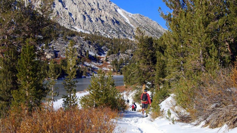
Lower Rock Creek Trail: This lovely, multi-purpose trail is one of the last in Mono County to become snow-covered and one of the first to melt out in the spring! It follows the icy, rushing creek through stands of silver aspen, and offers glimpses of inspiring mountain peaks. The trail is narrow and can be icy so poles are a wise idea. There are pull-out parking areas at three locations along Lower Rock Creek Road, just south of the Tom's Place exit off US 395. It's a "there-and-back/up-and-down" trail, so if you prefer to walk downhill first, park at the uppermost pull-out right at the top of the road. TIP: Although this trail is much less busy than in summer months, be on alert for mountain bikers and anglers.
East Fork Trail: Exit US 395 at Tom's Place and purchase a US Forest Service Sno-Park Pass at Tom's Place Resort (or buy one ahead of time at the Mammoth Lakes Welcome Center or Bishop Chamber of Commerce & Visitor Center in Bishop – or purchase online at https://www.fs.usda.gov/recarea/inyo/recarea/?recid=81528). Drive approximately six miles up Rock Creek Road until you reach the winter road closure Sno-Park gate. Parking is roadside, and the East Fork trailhead is located just before the gate on the south side of the creek. After walking several hundred feet on the south side of the trail, you will cross a wide footbridge -- the remainder of the trail winds gently uphill on the north side of the creek for about two miles, then climbs steeply to Rock Creek Lake. TIP: For most hikers, the best turn-around place is at Rock Creek Lodge, about a mile before the steep climb to Rock Creek Lake. At this point, you can follow the Lodge access road a short ways out to Rock Creek Road and then hike back to your vehicle along the road, making your trek a beautiful loop. Please note: If there has been a recent snowstorm with more than a few inches of snow, or it’s a big snow year, the East Fork Trail may not be accessible without snowshoes -- see the alternate option below.
Upper Rock Creek Road: If the East Fork trail is inaccessible due to snow, or if you'd prefer a wide, more expansive track, an excellent option is to walk (if hard-packed) or snowshoe or cross-country ski up snow-covered Rock Creek Road! You may walk all the way to Rock Creek Lake, about 4 miles, one way. TIP: In late spring, depending on snow melt and snow plowing schedule of both Mono and Inyo counties, Rock Creek Road may be opened to vehicles up to Rock Creek Pack Station. Walk down the road to Rock Creek Lake, or more fit hikers could walk 1.2 miles along the narrow road to the scenic Little Lakes Valley trailhead. If the trail is boot-packed, you may hike in potentially as far as Heart Lake. This will be 4-5 miles each way with some tricky footing so plan to start early and definitely bring trekking or ski poles, food and water.
Convict Lake: Just two miles off US 395, Convict Lake is one of the most dramatic, photogenic lakes in the Eastern Sierra, and it’s even more striking in winter! There is a lakeside trail that starts from the Marina parking area and goes half-way around the lake to a boardwalk through an old aspen grove. It is not recommended to continue hiking beyond the boardwalk -- the south side of the lake is steep and prone to snow and mudslides. TIP: Convict Lake Resort is open year-round and the fine dining restaurant is excellent. Reservations are recommended -- or enjoy the more casual atmosphere in the lounge, a great apres-hike option.
Upper Owens River: Driving south on US 395 from Mammoth Lakes, exit at Benton Crossing Road (at the "Green Church" landmark). At about 6.5 miles, you will cross the Benton Crossing Bridge, after which you will see a dirt road and parking area on the left/north side. If you don't have snowshoes, this popular winter fishing spot could potentially be covered in snow that is too deep or soft for walking. However, the Owens River area gets optimal sunshine and the trail along the banks of this meandering, beautiful river is often boot-packed by fishing enthusiasts. TIP: The views east to the Sierra mountain range will knock your wool socks off, so be sure to bring your camera!
Hot Creek Geological Site: Just 9.5 miles south of Mammoth Lakes, Hot Creek Geological Site is a great place for a winter hike with a one important note of caution! Hot Creek Hatchery Road is NOT paved or plowed and most vehicles cannot navigate the deep snow, and icy/muddy conditions in winter. Don’t risk getting stuck! Please park in the available roadside pull-outs before the road becomes snow, slush or ice and walk in to the Hot Creek trailhead – roughly 2 miles, each way. The hike down to the canyon floor offers awesome views of the steaming geothermal hot springs, and you may hike along the south side of the creek for a stretch to admire the rugged canyon and the softly flowing creek. TIP: Watch for owls, eagles, hawks and other birdlife who feast on the creek’s brook trout. PLEASE NOTE: The bubbling, aquamarine hot springs have been closed for bathing since 2006 due to dangerous, scalding temperatures, and the immediate shoreline is unstable. Keep your distance and do not cross fenced areas.
Mammoth Lakes Basin: Just a few minutes’ drive up Lake Mary Road right from the Village at Mammoth, the Tamarack Cross-country Ski Resort offers 35 km of groomed Nordic ski track which requires a purchased trail pass to ski. However, the eastern prong of the trailhead has a parallel groomed track for free public access. If the snow is hard-packed, you can easily walk without snowshoes or skis. The steady but relatively gentle uphill trail brings you to jaw-dropping Lake Mary with views of iconic Crystal Crag. Continue on the public access trail to Lake Mamie and take in the beautiful vista below to Twin Lakes, walking the final stretch to Horseshoe Lake. Round trip from the parking area to Horseshoe Lake is about 6 miles. Parking can be a challenge at this popular spot, so please consider taking the free public transportation from the town of Mammoth Lakes (ESTA link?). TIP: Dogs are welcome but must be leashed at all times. Please do NOT cross from the public access trail to the groomed Nordic track -- not only do the skiers fly by quickly, but your footprints leave frozen holes that can cause accidents for skiers.
June Lake Loop: State Route 158 is a 15km horseshoe-shaped route leaving US 395 at two separate junctions. Known as the June Lake Loop, the mid-section curve of the "horseshoe" is closed to traffic in winter due to snow -- but open to pedestrians, snowshoers, and Nordic skiers! You have two choices to begin your walk – exit US 395 at the north end of SR 158, park at the gate closure which is about 2 miles, and walk alongside magnificent Grant Lake where there are incredible views and few people. Or exit US 395 at the south end of SR 158, drive through charming June Lake Village (excellent spot for lunch, an apres-hike beer at June Lake Brewing, or to pick up a few groceries!) to the gate closure just past the Double Eagle Resort & Spa, and walk to the incomparable Silver Lake. The road is flat, and strong hikers can certainly trek the entire closed route, but it is about 10 miles each way with slower-than-summer walking speeds, so it is recommended to bring two vehicles and leave one at either end! TIP: Mornings are best for this winter walk as the packed snow on the road gets softer as the day heats up and punching through soft snow – the dreaded post-holing – is never fun.
Parker Lake: At the north end of SR 158 / June Lake Loop, vehicle access to the Parker Lake trailhead and parking area is possible if the weather has been clear and sunny for a stretch, and you have a good 4WD vehicle, (the road to Parker Lake trailhead is not plowed). The 2.5-mile Parker Lake trail is usually boot-packed but it has steep sections that require hiking boots and trekking poles. On the descent back to the parking area, the views of distant Mono Lake and Mono Basin are spectacular.
TIP: Bring a lunch and a thermos of hot chocolate as beautiful Parker Lake is a picnic-worthy destination!
Lee Vining Creek Trail: Located at the north end of the village of Lee Vining, the trailhead begins behind the Mono Basin Scenic Area Visitor Center (please note that the visitor center is closed in the winter months). With beautiful views of salty, blue-green Mono Lake, the trail winds down to creek level for about 4 miles, ending at the south end of town! You may then retrace your steps along the trail once again, or walk back to your vehicle through charming Lee Vining.
TIP: The Mono Lake Committee Visitor Center & Book Store is open year-round from 9am-5pm and offers a free 30-minute film The Mono Lake Story. Restrooms and public Wi-Fi are also available.
Tioga Pass Road/Poole Plant Road: For a serene and spectacular walk along a plowed (sometimes icy/snowy) scenic road, exit US 395 at Tioga Pass Road/SR 120 just south of Lee Vining. Drive for about 4 miles to Poole Plant Road, right before the closed gate (access to the eastern entrance to Yosemite National Park is closed in winter, usually from late November to late May/early June). Park off the road and begin this wow-factor walk along Poole Plant Road, surrounded by aspens and the towering majesty of mountains. For a 2-mile walk each way, Aspen Campground (closed in winter) along Lee Vining Creek is a great destination with snow covered sage meadows, thick aspen stands, and jutting mountain peaks. TIP: Walking farther along the road, beyond the campground, is possible but the road gets more heavily forested and therefore chillier – shadowed even on the sunniest winter day – and views are obscured.
Mono Lake and South Tufa State Natural Reserve: One of the most unique and special places in the Eastern Sierra – and in the entire world, actually – Mono Lake is a must-see with its snow-dusted tufa formations and ocean-like expanse. Exit US 395 at SR 120 West (signs will say Benton/South Tufa). While SR 120 West is closed just beyond the South Tufa road, the 5-mile open section to the gate is paved and plowed regularly. Do watch out for deer, wild mustangs, coyotes, hares, and other wildlife – especially White Tail Deer. In winter, the dirt road to the South Tufa parking lot may or may not be plowed or open. If it is not open to vehicles, then park roadside, and walk, snowshoe or ski. The South Tufa boardwalk and nature trail is about two miles from the main road. TIP: Due to its high salt-water content (almost three times saltier than the ocean), Mono Lake does not usually freeze. If it is iced over, do not walk on it – it is not stable! A great way to learn more about this fascinating, special place is to drop by the Mono Lake Committee Visitor Center & Bookstore in Lee Vining. It is open year-round from 9am to 5pm daily, offering a free 30-minute documentary film called The Mono Lake Story, well worth watching.
Bridgeport Winter Trail System: A newest addition to groomed, free winter recreational opportunities in Mono County, this serene, multi-use trail is located right in the beautiful backyard of historic Bridgeport. The track winds gradually uphill for 4.25 miles (each way) to the Buckeye Hot Springs day-use area. Exit US 395 at Twin Lakes Road at the north edge of Bridgeport. Watch for Buckeye Road to the north, about 7 miles along, at Doc and Al’s Resort. Grooming and plowing operations are based on weather and snow conditions. Please do not walk in the cross-country ski track, and kindly respect other trail users! TIP: Nestled under the rock face jutting up from Buckeye Creek, the Buckeye natural hot springs steam in the crisp winter air. Usually in winter, however, the hot springs are not warm, and soaking is not recommended.
Bridgeport Winter Recreation Area (BWRA): Located halfway between the towns of Bridgeport and Walker, SR 108 to Sonora Pass is plowed until the People's Gate closure, 5.7 miles from Sonora Junction at US 395. From the gate, the road is unplowed and accesses an abundance of wilderness terrain, popular with snowmobilers and skiers. You may walk along the road (if hard-packed) but do bring snowshoes or cross-country skis in case the snow is soft or deep. The road climbs steadily for about 2.5 miles to the Leavitt Meadows campground and day-use area which is a good turn-around point. TIP: If the snow is not too deep, walk through the campground towards the river to the pedestrian bridge that spans the snowy, rushing West Walker River below. On low-snow years, and for well-prepared hikers, the trail continues on the south side of the river to Lane and Roosevelt Lakes!
West Walker River Preserve: At the south end of the town of Walker, right on Larson Lane, the West Walker River Preserve (formerly called Aspen Glen Reserve) offers 89 acres of snowy riparian meadows, cottonwood trees, and wetlands, including a one-mile trail along the east shore of the West Walker River. While the drier climate and lower elevation of Northern Mono County means that snow may not be as deep or stick around as long as in other parts of the county, snowshoes may be helpful for exploring the Preserve off-trail. TIP: Dogs on leash are welcome, as are anglers interested in catch-and-release winter fishing, (fishing license required and special regulations apply).
For more information about winter hiking, please contact Mono County Tourism at www.MonoCounty.org or 800-845-7922.