Things to Do
John Muir Trail
"In every walk with nature one receives far more than he seeks."
John Muir
One of the Most Scenic Trails in the U.S.
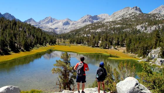
The John Muir Trail is one of the most scenic trails in the U.S. It spans over 200 miles of remote, pristine wilderness in California's Sierra Nevada mountains. Each year, hikers come from all over to hike parts or all of the trail. The trail begins in Yosemite National Park, and continues 215 miles through the Ansel Adams Wilderness, Sequoia National Park, Kings' Canyon National Park and ends at the highest peak in continental United States, Mt. Whitney (14,496 ft.).
TIP: Make sure to visit our page on the Pacific Crest Trail as well for more useful information because the Pacific Crest Trail and the John Muir Trail coincide with one another for most of its length. You can also find great information on The Pacific Crest Trail Association's website for both trails.
Permits & Fees
If you plan to hike the John Muir Trail as a continuous hike, you only need one wilderness permit and do not need a "Whitney Stamp". Most people begin their trip out of Yosemite Valley, which is the traditional start point for the JMT. However in recent years, many start their trip out of Lyell Canyon (Tuolumne Meadows) because permits for this trailhead are significantly easier to obtain.
Northern Starts
Yosemite Wilderness Permit Reservations are available 24 weeks (or 168 days) in advance. For each day, 60% can reserved ahead of time. The remaining 40% are available on a first-come, first-served basis. Hours for picking up these first-come, first-served permits are from 11 am the day before your hike begins until the station closes. To see which trailheads are full, please click here. TIP: Start requesting your reservations exactly 168 days before your trip to have the best chance at obtaining the permits you wish to have for your trip.
Southern Starts
Whitney Portal Permits for the JMT can be reserved bia Recreation.gov. These permits are extremely popular and are issued via the lottery system, as explained on our Mt. Whitney page. Applications to be entered into the lottery are accepted from February 1st through March 15th and can be done online. Start dates in July, August and September usually fill completely by the lottery system.
After the lottery is complete, remaining spaces are made available through the online system starting April 1st. From April 1st until 2 days before your trip entry date, reservations can be made online or through Recreation.gov or through their call center, which can be reached at 1-877-444-6777.
Spaces are not saved for walk-in permits and all permits must be picked up at the Eastern Sierra Inter-Agency Visitor Center located in Lone Pine, CA.
NOTE: The official southern entry point of the JMT is on the summit of Mt. Whitney, and most people access the summit from Whitney Portal which is a trip of about 11 miles. Many hikers say that this is the "harder" entry than the Northern point out of Yosemite, but to each his own.
Alternate Trailheads
While the two listed above are the two most popular ways to enter onto the John Muir Trail, there are other alternate routes.
For a complete list of these alternate routes and where along the JMT they connect, please click HERE.
Food Storage & Bear Canisters
Food canisters are required for the John Muir Trail (and Pacific Crest Trail) and there are no exceptions for through hikers on these trails. You may rent a bear canister for the duration of your trip at any wilderness area permit station.
Food Caches
Ranger stations do not accept food packages. Post offices in Yosemite Valley and Tuolumne Meadows accept food packages mailed care of General Delivery. Please remember to mark packages with "hold for hiker until (date)" because packages that are not marked with this information will only be held for a 14 day period.
What to Expect
The primary hiking season is usually from July through September, though snow may linger the closer to shoulder seasons you get, as well as almost always on higher passes. While summer hiking conditions are typical with nice, sunny, blue skies and warm weather, afternoon thunderstorms and colder weather is not unheard of in the high county of the Sierra. Make sure you are prepared for the bad weather to prevent hypothermia.
About 75-90% of hikers typically start from Yosemite and travel north to south towards Mt. Whitney. There are advantages to starting in Yosemite and hiking south, like starting at a lower altitude such as Yosemite Valley allows a hiker to slowly acclimate to the increasing elevations. In addition, there are several resupply points convenient to the JMT during its northern half, which allow hikers to carry a lighter good load in the beginning stages of their trips and to have many exit sites in case problems should arise.
NOTE: The southern half of the JMT is more remote and generally higher in elevation, thus making it more appropriate for the second half of the hike. If you choose to start from the south and travel north, make sure you are prepared and know what you are getting yourself in to.
Regardless of your experience, make sure that you acquire as much knowledge and understanding and experience as you possibly can before trying to tackle the JMT or PCT. These are strenuous, advanced hikes and should be prepared for as such. Make sure to test your gear (and yourself) before heading out on your trip on the John Muir Trail.